Tocht Andere activiteiten Val de Bagnes - 2005_06_16_Fionnay-Panossière-Otanes-Bonatchiesse-Fionnay - Photo

2005_06_16_Fionnay-Panossière-Otanes-Bonatchiesse-Fionnay

 daniel59
daniel59

Gebruiker

© OpenStreetMap contributors
Lengte
Lengte
17 km
Max. hoogte
Max. hoogte
2866 m
Positief hoogteverschil
1492 m
Km-Effort
Km-Effort  
37 km
Min. hoogte
Min. hoogte
1486 m
Negatief hoogteverschil
1499 m
Boucle
Boucle
Ja
Datum van aanmaak :
2014-12-11 00:00:00.0
Laatste wijziging :
2014-12-11 00:00:00.0

(0 Bericht)

Andere activiteiten
Andere activiteiten
--
Moeilijkheid : Onbekend

Scan deze QR-code om de tocht te openen in de SityTrail-applicatie

Gratisgps-wandelapplicatie

Logo SityTrail SityTrail

IGN / Geografische instituten

SityTrail uit de App Store downloaden SityTrail uit Google Play downloaden

Logo SityTrail SityTrail World

De wereld gaat voor u open

SityTrail uit de App Store downloaden SityTrail uit Google Play downloaden SityTrail op Huawei AppGallery downloaden

Over ons

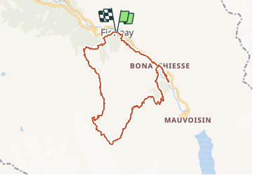
Tocht Andere activiteiten van 17 km beschikbaar op Valais/Wallis, Entremont, Val de Bagnes. Deze tocht wordt voorgesteld door daniel59.

Beschrijving

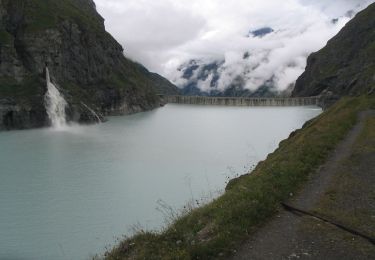
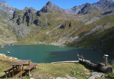
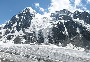
Malgré que le gardien de la cabane Panossière a déconseillé le tour, après téléphone à un guide je me suis "lancé" avec Florence. Aucun problème jusqu''à la cabane, quasiment aucun névé à traverser. A la cabane volets ouverts et le drapeau est pendu! Il ne flotte même pas, car il n''y a pas un courant d''air. Personne à la cabane! Température très agréable, vue magnifique sur le Gd-Combin d''un blanc immaculé!

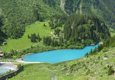
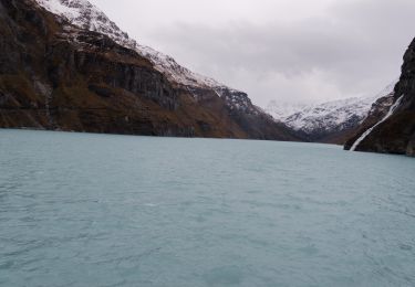
Après une bonne pause dans un coin de rêve nous poursuivons notre chemin par le col des Otanes. La traversée du col est "pénible", nous enfonçons à chaque pas largement au-dessus des genoux! Heureusement le névé "plongeant" sur Bonatchiesse "porte". Le piolet a été utile (pas indispensable) dans quelques passages.

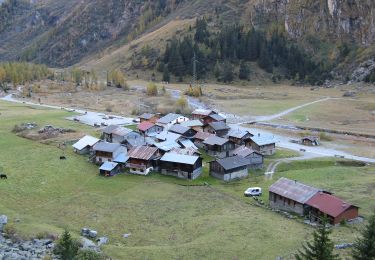
Un petit arrêt au bistrot de Bonatchiesse, une visite du camping pour savoir si Florence peut venir avec son camping-car! Et retour à Fionnay.

J''oubliais, il y avait encore ma chienne Nigelle qui comme nous était toute contente de sa journée.

Belle journée, nous avions RDV à 6h30 à Châtel-St-Denis, nous étions de retour à 18h30! Sans attente à Glion ...

P.S. Le dénivelé affiché est faux!

Hoogteprofiel

Plaatsbepaling

Land:
Switzerland
Regio :
Valais/Wallis
Departement/Provincie :
Entremont
Gemeente :
Val de Bagnes
Locatie:
Unknown
Vertrek:(Dec)
Vertrek:(UTM)
369011 ; 5099054 (32T) N.

Wandeltochten in de omgeving

Tocht Te voet Val de Bagnes - Barrage de Mauvoisin - Le Pleureur - Photo
Te voet
PRO

Te voet

Medium
Val de Bagnes, Valais/Wallis, Entremont, Switzerland
4,3 km | 23 km-effort
5h 11min
Neen
Tocht Te voet Val de Bagnes - Pazagnou-Col des Otanes - Photo
Te voet
PRO

Te voet

Gemakkelijk
Val de Bagnes, Valais/Wallis, Entremont, Switzerland
4 km | 11,6 km-effort
2h 38min
Neen
Tocht Te voet Val de Bagnes - Fionnay-Bonatchiesse - Photo
Te voet
PRO

Te voet

Gemakkelijk
Val de Bagnes, Valais/Wallis, Entremont, Switzerland
4,5 km | 6,3 km-effort
1h 26min
Neen
Tocht Te voet Val de Bagnes - Louvie-Fionnay - Photo
Te voet
PRO

Te voet

Gemakkelijk
Val de Bagnes, Valais/Wallis, Entremont, Switzerland
3,7 km | 6,3 km-effort
1h 26min
Neen
Tocht Te voet Val de Bagnes - Col Termin-Louvie - Photo
Te voet
PRO

Te voet

Gemakkelijk
Val de Bagnes, Valais/Wallis, Entremont, Switzerland
3,8 km | 6,3 km-effort
1h 25min
Neen
Tocht Stappen Val de Bagnes - Mauvoisin Bonatchiesse - Photo
Stappen
michauxpaul

Stappen

Moeilijk
Val de Bagnes, Valais/Wallis, Entremont, Switzerland
8,7 km | 16,2 km-effort
3h 40min
Ja
Tocht Te voet Val de Bagnes - Promenade de la Dranse - Photo
Te voet
PRO

Te voet

Gemakkelijk
Val de Bagnes, Valais/Wallis, Entremont, Switzerland
7,1 km | 9,4 km-effort
2h 8min
Neen
Tocht Te voet Val de Bagnes - Panossière-La Maye - Photo
Te voet
PRO

Te voet

Gemakkelijk
Val de Bagnes, Valais/Wallis, Entremont, Switzerland
3,8 km | 6,4 km-effort
1h 27min
Neen
Tocht Te voet Val de Bagnes - Bonatchiesse-Mauvoisin - Photo
Te voet
PRO

Te voet

Gemakkelijk
Val de Bagnes, Valais/Wallis, Entremont, Switzerland
3,2 km | 6,1 km-effort
1h 22min
Neen


Sluiten
Mijn abonnementen